
The Fernhurst Society
Fernhurst in Living Memory, part 2
Railways That Never Were
by Iain Brown, 2004.
- from information provided by Mr Antony Hemans. John Rickman in his book on the The Land of Lod (1998) similarly drew from this source in his chapter on “Ghost Trains”.
Click on any image to see a larger version (note: the larger images may take a minute to download over slow internet connections).
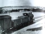
1950 steam train toward Selham
1950: a steam train toward Selham, between Midhurst and Petworth
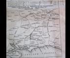
1846 Sussex railway map
A map dated 1846 - the same date as our Tithe Map. Note that there are no railways in the immediate vicinity.
The maps below show the progressive invasion of the iron railroads:-
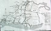
1865 Midhurst-Haslemere railway extension
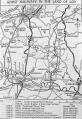
1867 Sussex railway map
Map of 1867, showing the London to Portsmouth line and some of the proposed extensions.
route of proposed Midhurst-Haslemere railway
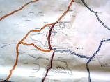
A map from the book The Land of the
Lod showing the proposed alignment of the Midhurst-Haslemere extension
through the western edge of Fernhurst Parish.
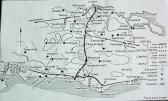
the proposed rail network

route of proposed tunnel south of Haslemere
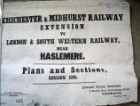
plans for the Midhurst-Haslemere extension
Copy of some of the information available for study at the West Sussex County Council Records Office in Chichester (illustrated here is the cover page of the plans for the proposed Midhurst to Haslemere line going through the north west portion of Fernhurst Parish).
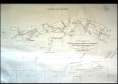
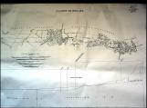
Midhurst-Haslemere extension: surveyor's plan (1)
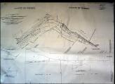
Midhurst-Haslemere extension: surveyor's plan (2)
Midhurst-Haslemere extension: surveyor's plan (3)
The next three photos show some of the detailed engineering drawings relevant to the relevant to the railway route through Fernhurst Parish.
The route out of Midhurst started towards Stedham, through Iping then Redford and on to Fernhurst Parish at Elmer’s Marsh. Then, skirting the fields of Lower Lodge Farm, passed Tribes Barn to Shulbrede Priory then by a tunnel of 1,089 yards in length under Marley Heights / Common to arrive at Shottermill Ponds and hence via today's Kings Road to Haslemere Station.
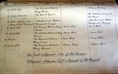
landowners along the route
A photo listing some of the landowners who would have been involved in permitting the railroad over the proposed route.
The local landowners along the way were "all for" the proposed new rail link but an Act of Parliament of 1865 was never enacted since the sponsor, the London to Brighton South Coast Railroad Company under the Chairmanship of one Leo Schuster got into financial difficulties by spending £8m, a lot of money in those days, in unauthorised rail road extensions. The Schuster family came later to reside in Fernhurst at Verdley House.
Imagine how Fernhurst Parish, and the lives of the people who lived there, might have been changed if the railway had been built.
The Fernhurst Archives
